
Your Card
Location
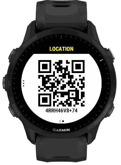
Reading “minus thirty-three point eight six eight…” to a dispatcher is slow and easy to get wrong. The Location page gives a country, a short code and exact coordinates, plus a QR code that opens your position in a map.
4RRH46V8+74, that names a small area of the Earth. A dispatcher can type it into Google Maps, and it is much easier to read out than latitude and longitude. How it works · plus.codes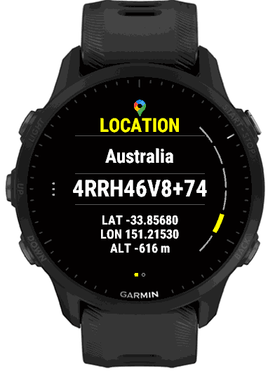
What it shows
- Country
- The country the GPS places you in, worked out on the watch from your position. There is no street, city or state on this page: the Plus Code and coordinates are what a dispatcher needs.
- Plus Code
- Your position as a Plus Code in large text, such as
4RRH46V8+74. - LAT and LON
- Latitude and longitude to five decimal places, about a metre.
- ALT
- Your altitude in metres, from the watch.
Until the watch has a GPS fix, the page says Acquiring GPS fix…. Outdoors with a clear view of the sky, it normally takes a few seconds to a minute. Indoors it may not arrive at all.
The QR code
Press START on the Location page (or tap) to show a QR code with your Plus Code underneath. A responder who scans it with a phone camera is taken to Google Maps at that spot, with directions. This needs a GPS fix, so the QR page does not open while the page still says Acquiring. Swipe left or right, or press BACK, to close it.
Plus Codes, and why not only latitude and longitude
A Plus Code (also called an Open Location Code) is a short, shareable code for a small area of the Earth, an open standard created by Google so places without a street address can still be found precisely. The part after the + pins down the spot within the area named before it.
It is shorter than a pair of decimal coordinates, harder to garble over the phone, and can be typed straight into Google Maps. The latitude and longitude are on the same page for anyone who wants them.
Reading one: each pair of characters narrows the area. The first four, such as 4RRH, name an area about 110 km across; the next two, 46, about 5 km; the next two, V8, about 275 m; and the two after the +, 74, about 14 m. EmergencyAid shows the full code, so it works anywhere without needing the name of a nearby town.
Learn more, or paste a code to see where it is, at plus.codes, the open standard’s own site.
GPS and battery
EmergencyAid does not track you. Garmin keeps the watch’s last known position, and EmergencyAid uses that when it opens to pick the country for Local Help. It then asks for a live GPS fix for up to a minute, and again whenever the Location page is on screen. As soon as you leave the page the GPS is switched off. Your position is not recorded, and the watch does not send it anywhere; it is shown only on screen and in the QR code you open yourself.
Turning the page off
In Settings, open Location and turn Show off to leave the page out of the card. On the phone it is the Show location switch in the Location group.